McCormick Ranch
A central, established master plan with greenbelt paths, lakes and easy access to Old Town.
A central, established master plan with greenbelt paths, lakes and easy access to Old Town.
Figures for October 2026 (the latest full month), from RentCast listings in ZIP 85258, which extends well beyond McCormick Ranch.ZIP-wide median list price (single-family listings): RentCast, ZIP 85258 (which extends well beyond McCormick Ranch), October 2026.ZIP-wide median days on market (single-family listings): RentCast, ZIP 85258 (which extends well beyond McCormick Ranch), October 2026.Updated
Market figures: RentCast, from single-family listings (list prices, not closed sales) in each area’s main ZIP code. “To date” means the month so far. Silverleaf shares ZIP 85255 with North Scottsdale, so it shows no ZIP market figures of its own. Any figures shown are past results, not a forecast. Descriptions cover places and housing, not who lives there.
Drive times are by car without traffic, so off-peak; rush hour takes longer. They were measured on November 12, 2026 from the middle of McCormick Ranch’s outline on this site’s map to each place’s nearest way in, using OSRM on OpenStreetMap roads.How the drive times were measured: Sky Harbor: Phoenix Sky Harbor International Airport, Terminal 4’s nearest edge; Old Town: Old Town Scottsdale: the nearer of Scottsdale Fashion Square, where Old Town starts, and the Scottsdale Civic Center at its middle; Scottsdale Airport: Scottsdale Airport (SDL), the City’s terminal building; Loop 101: the nearest Loop 101 interchange; OpenStreetMap: the roads and places routed on (© OpenStreetMap contributors); Project OSRM: the open routing engine used
Aaron’s sales
Aaron has closed 15 sales in McCormick Ranch since August 2014.
Indian Bend Wash Greenbelt · 11 lakes · 15 pocket parks · Old Town about 10 minutes’ drive
The City of Scottsdale’s greenbelt of parks, lakes, paths and golf courses, along Hayden Road through the Ranch. Its 11-mile path has more than 24 underpasses and bridges.Source: City of Scottsdale, Paths and trails (Indian Bend Wash greenbelt); Experience Scottsdale, Scottsdale’s Indian Bend Wash Greenbelt
The property owners’ association keeps the Ranch’s lakes. Fishing is catch and release, with permits only for owners and their tenants, and swimming is prohibited.Source: McCormick Ranch Property Owners’ Association, Rules and Regulations (PDF)
A City park about 5 minutes’ drive, with a ride-on railroad, a 1950s carousel, playgrounds, a splash pad and a railroad museum.Source: McCormick-Stillman Railroad Park; OpenStreetMap: road distance and drive time by car from the middle of the area’s outline on this site’s map to each place’s nearest way in, routed with OSRM, without traffic, measured 2026-11-10; Project OSRM: the open routing engine used
A City park on the greenbelt, about 6 minutes’ drive, with a grass dog park, an inclusive playground, and ramadas and courts you can reserve.Source: City of Scottsdale, Chaparral Park; OpenStreetMap: road distance and drive time by car from the middle of the area’s outline on this site’s map to each place’s nearest way in, routed with OSRM, without traffic, measured 2026-11-10; Project OSRM: the open routing engine used
Two courses, the Palm and the Pine, about 5 minutes’ drive, open all year with tee times booked online or by phone. It has a restaurant and a driving range.Source: McCormick Ranch Golf Club: Golf; OpenStreetMap: road distance and drive time by car from the middle of the area’s outline on this site’s map to each place’s nearest way in, routed with OSRM, without traffic, measured 2026-11-10; Project OSRM: the open routing engine used
Scottsdale’s downtown of shops, more than 100 restaurants, galleries and museums, about 10 minutes’ drive. By bike, the Arizona Canal path runs there from the greenbelt.Source: Experience Scottsdale, Old Town fact sheet; OpenStreetMap: road distance and drive time by car from the middle of the area’s outline on this site’s map to each place’s nearest way in, routed with OSRM, without traffic, measured 2026-11-10; Project OSRM: the open routing engine used; SRP, Canal trails; OpenStreetMap: the Arizona Canal path and the Indian Bend Wash Greenbelt path, measured 2026-11-08
Drive times and distances are by road from the middle of the area’s outline on this site’s map, without traffic (OSRM on OpenStreetMap, measured November 10, 2026).
See Aaron’s own listings, and search homes for sale from every brokerage.
The search shows the homes inside McCormick Ranch as the site’s map draws it, about Scottsdale Road to Pima Road and Indian Bend Road to Shea Boulevard; ZIP 85258 reaches well beyond it.
Search homes for sale from every brokerage that shares its listings through ARMLS, refreshed several times a day. Save the ones you like, with no account, and ask Aaron about any of them: he can show you any of these homes and represent you as your buyer’s agent.
Search homes for sale in McCormick RanchMcCormick Ranch HOA fees, rules and lakes
Two homes with the same price per square foot can still differ on these.
Boundaries are approximate. The list and links on this page carry the same information.
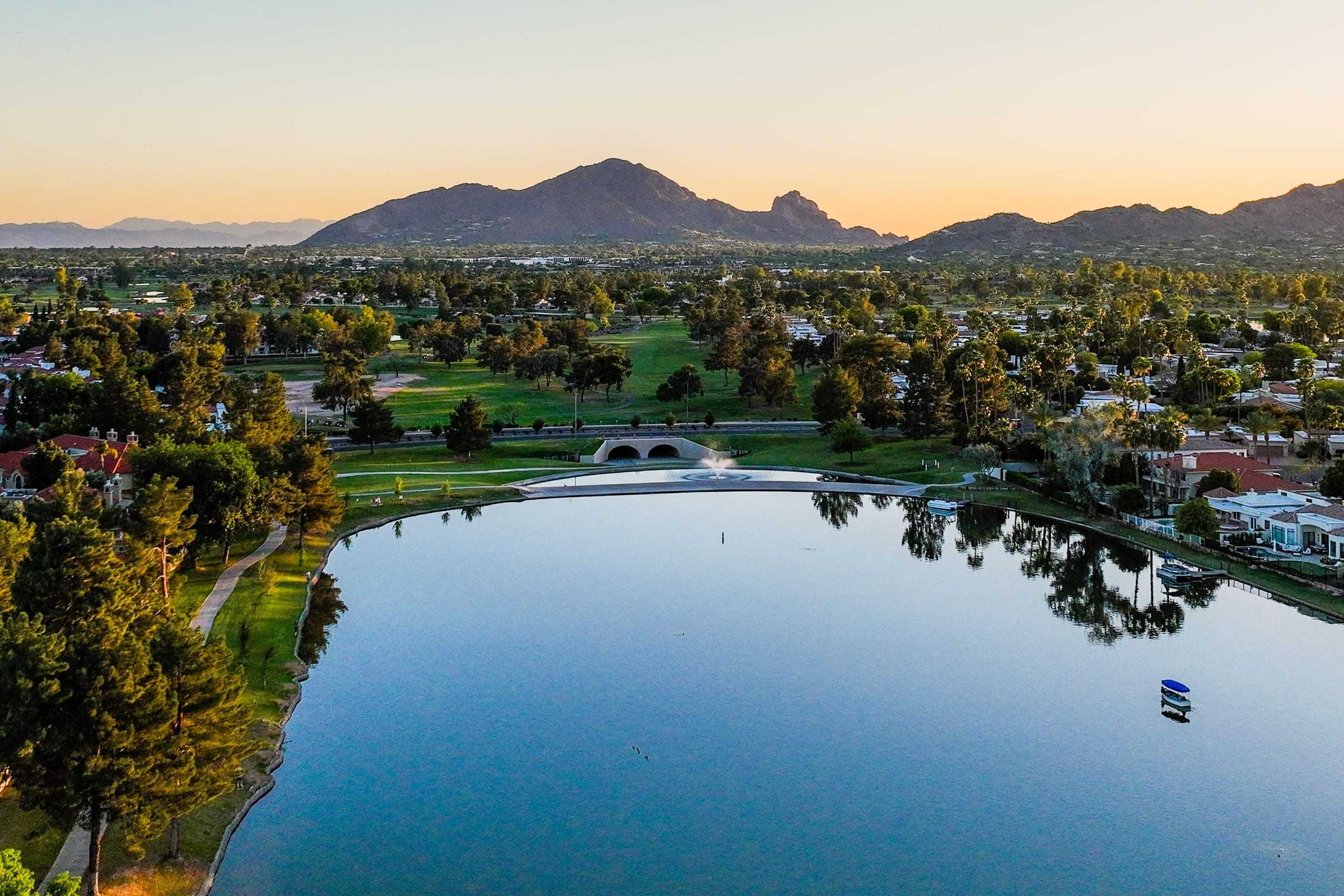
McCormick Ranch is built around water and green space. Its property owners’ association counts over 20 miles of walking paths, 11 lakes and 15 pocket parks. Through the middle, along Hayden Road, runs the City of Scottsdale’s Indian Bend Wash Greenbelt: 11 miles of parks, lakes, paths and golf courses, from Shea Boulevard south to Tempe Town Lake.Source: McCormick Ranch Property Owners’ Association, The Rancher, spring/summer 2026; City of Scottsdale, Indian Bend Wash Greenbelt; Experience Scottsdale, The Indian Bend Wash Greenbelt
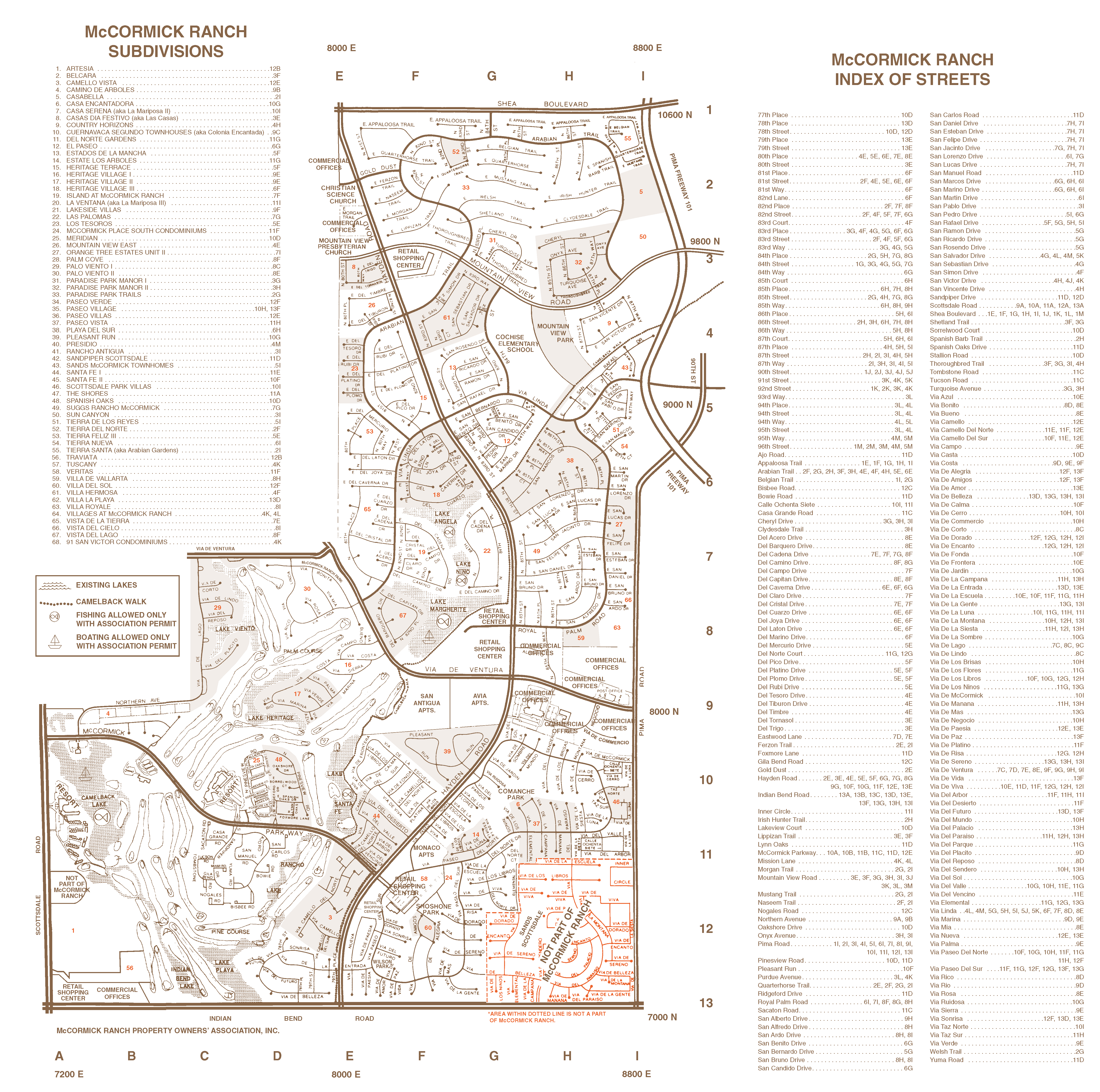
Most of the lakes and paths are in the middle of the Ranch, around Hayden Road and the golf courses. The association’s map names Camelback Lake, Lake Margherite, Lake Angela, Lake Nino and Santa Fe Lake among the lakes, and Camelback Walk, a path running northeast toward Shea Boulevard.
The association keeps the greenbelts, paths and lakes, and only owners and their tenants can get lake permits. Fishing is catch and release, with artificial lures, on five lakes. Boating is on Camelback Lake and Lake Margherite, in boats with an electric motor, oars, paddles or sails. Swimming isn’t allowed.Source: McCormick Ranch Property Owners’ Association, community map with subdivisions (2022); McCormick Ranch Property Owners’ Association, The Rancher, fall/winter 2025 (the greenbelt, the 2026 budget and the shopping center directory); McCormick Ranch Property Owners’ Association, Rules and Regulations, version MRPOARRv_092026
Show on the map
Old Town, Scottsdale’s downtown of shops, more than 100 restaurants, galleries and museums, is about 10 minutes’ drive from the middle of the Ranch, without traffic. It starts about 2.5 miles down Scottsdale Road from Indian Bend Road, the Ranch’s southern edge, at Scottsdale Fashion Square.
By bike, take the greenbelt south to the Arizona Canal path, just past Indian Bend Road, and follow the canal to the Scottsdale Waterfront in Old Town. SRP’s canal paths are free and open to pedal bikes, but not motor vehicles. The greenbelt path carries on south toward Tempe Town Lake, with more than 24 underpasses and bridges at the streets it crosses.Source: OpenStreetMap: road distance and drive time by car from the middle of the area’s outline on this site’s map to each place’s nearest way in, routed with OSRM, without traffic, measured 2026-11-10; Project OSRM: the open routing engine used; OpenStreetMap: Scottsdale Road, Indian Bend Road, Camelback Road, the Arizona Canal path and the Indian Bend Wash Greenbelt path, measured 2026-11-08; Experience Scottsdale, Old Town fact sheet; SRP, Canal trails; City of Scottsdale, Path & Trail System; Experience Scottsdale, The Indian Bend Wash Greenbelt
Show on the map
Mountain View Park, with a community center, and Comanche Park are City parks inside the Ranch. Across Indian Bend Road from its southwest corner, about 5 minutes’ drive, McCormick-Stillman Railroad Park has a ride-on railroad, a 1950s carousel, playgrounds, a splash pad and a railroad museum.
Chaparral Park, south on the greenbelt at 5401 N. Hayden Road, is about 6 minutes’ drive, with a grass dog park, an inclusive playground, and ramadas and courts you can reserve.
For errands, the association’s directory lists Mountain View Plaza, the Shops on Hayden, Paseo Village and The Grove at McCormick, and Scottsdale Seville, and The Shops at Gainey Village are about a mile by road. HonorHealth Scottsdale Shea Medical Center is at 9003 E. Shea Blvd., near the Ranch’s northeast corner.Source: City of Scottsdale, Mountain View Park; City of Scottsdale, Comanche Park; City of Scottsdale, McCormick-Stillman Railroad Park; McCormick-Stillman Railroad Park; City of Scottsdale, Chaparral Park; HonorHealth, Scottsdale Shea Medical Center; McCormick Ranch Property Owners’ Association, The Rancher, fall/winter 2025 (the greenbelt, the 2026 budget and the shopping center directory); OpenStreetMap: road distance and drive time by car from the middle of the area’s outline on this site’s map to each place’s nearest way in, routed with OSRM, without traffic, measured 2026-11-10; OpenStreetMap: road distances by car from the middle of the area’s outline on this site’s map, routed with OSRM and measured 2026-11-08; Project OSRM: the open routing engine used
Show on the map
36 holes on two courses, the Palm and the Pine.Source: McCormick Ranch Golf Club: Golf
Scottsdale Silverado Golf Club
An 18-hole, par 70 course.Source: Scottsdale Silverado Golf Club: home
The Roadrunner, 18 holes and par 70, and the Snake, a 12-hole short course. Formerly Starfire Golf Club.Source: Scottsdale Country Club: home; Scottsdale Country Club: The Roadrunner Course
Scottsdale Silverado, Scottsdale Country Club and Gainey Ranch are just outside the Ranch: Silverado to the south, Scottsdale Country Club across Shea Boulevard.
Every golf club in Scottsdale and Paradise Valley, compared
Neighborhood shopping center at Scottsdale and Indian Bend Roads.Source: Whitestone REIT: Scottsdale Seville; McCormick Ranch Property Owners’ Association: Neighborhood, Retail Centers
Shops at 7293 N. Scottsdale Road.Source: McCormick Ranch Property Owners’ Association: Neighborhood, Retail Centers
Paseo Village and The Grove at McCormick
Two neighboring centers at Hayden Road and McCormick Parkway.Source: McCormick Ranch Property Owners’ Association: Neighborhood, Retail Centers
The Village on Hayden and Mercado on Hayden, on Hayden Road between Royal Palm Road and Via De Ventura.Source: McCormick Ranch Property Owners’ Association: Neighborhood, Retail Centers
Shopping center at Hayden and Mountain View Roads.Source: McCormick Ranch Property Owners’ Association: Neighborhood, Retail Centers
Most of the Ranch’s centers have no website of their own; the association’s directory lists them. McCormick Ranch Property Owners’ Association: retail centers
The Shops at Gainey Villageabout 1 miles
Shops, dining and services
The Pavilions at Talking Stickabout 3 miles
Shopping center
Scottsdale Quarterabout 6 miles
Shopping, dining and entertainment district
Kierland Commonsabout 6 miles
Open-air shopping and dining center
Distances are by road, from the middle of the area’s outline on this site’s map.Source: OpenStreetMap: road distances by car from the middle of the area’s outline on this site’s map, routed with OSRM and measured 2026-11-08; Project OSRM: the open routing engine used
School districts covering McCormick Ranch as this page’s map draws it: Scottsdale Unified.
Which school a home is assigned to depends on the address. Confirm it with Scottsdale Unified’s school finder.
The Arizona Department of Education publishes a report card for every public school: azreportcards.azed.gov.
District boundaries from the U.S. Department of Education’s public data (2024–25). Aaron doesn’t rate or recommend schools.Source: National Center for Education Statistics, EDGE School District Boundaries (TIGER/Line 2025, school year 2024-25)
In Aaron’s experience, a big part of McCormick Ranch’s appeal is how far you can get on foot: the greenbelt and the lake paths lead to shops and restaurants. Rotary Park, on Doubletree Ranch Road, has a playground, and McCormick-Stillman Railroad Park, just across Indian Bend Road, has playgrounds and a splash pad.
The Ranch is central and right beside Loop 101, so the rest of the Valley is within reach. Scottsdale Fashion Square, Scottsdale Quarter and Kierland Commons are a short drive away.
In Aaron’s experience, many communities inside the Ranch are gated, Palm Cove and Las Palomas among them.
No, McCormick Ranch is a master-planned community in the City of Scottsdale, in ZIP code 85258. That ZIP code also covers neighboring areas.Source: McCormick Ranch Property Owners’ Association, Community History
Yes, the McCormick Ranch Property Owners’ Association, a non-profit run by an executive director and a board of directors. It has architectural control committees, so ask about its rules and whether the home also has a neighborhood HOA.Source: McCormick Ranch Property Owners’ Association, Community History; McCormick Ranch Property Owners’ Association, About
Mostly single-family homes from the 1970s through the 1990s, many of them updated, on typical suburban lots.
Moderately, and most of all on foot or by bike: the McCormick Ranch Property Owners’ Association counts walking paths of over 20 miles, 11 lakes and 15 pocket parks. The City of Scottsdale’s Indian Bend Wash Greenbelt runs through the Ranch along Hayden Road, and its 11-mile multiuse path has more than 24 underpass and bridge crossings. The association’s directory lists shopping centers along Hayden Road and at Scottsdale and Indian Bend Roads, and Old Town is about 2.5 miles south along Scottsdale Road.Source: McCormick Ranch Property Owners’ Association, The Rancher, spring/summer 2026; City of Scottsdale, Path & Trail System; Experience Scottsdale, The Indian Bend Wash Greenbelt; McCormick Ranch Property Owners’ Association, The Rancher, fall/winter 2025 (the greenbelt, the 2026 budget and the shopping center directory); OpenStreetMap: Scottsdale Road, Indian Bend Road, Camelback Road, the Arizona Canal path and the Indian Bend Wash Greenbelt path, measured 2026-11-08
It’s the City of Scottsdale’s flood-control greenbelt: in the City’s words, “an oasis of parks, lakes, paths and golf courses traversing 11 miles through the heart of Scottsdale.” It runs from Shea Boulevard south to Tempe Town Lake, back and forth across Hayden Road, and it was built to carry storm water through grass, lakes, parks and golf courses rather than a concrete channel. In McCormick Ranch, according to its property owners’ association, storm water flows through grassy greenbelts into lakes that serve as detention basins, including Lake Angela and Lake Margherite, and the golf courses store more before it reaches the wash.Source: City of Scottsdale, Indian Bend Wash Greenbelt; Experience Scottsdale, The Indian Bend Wash Greenbelt; McCormick Ranch Property Owners’ Association, The Rancher, fall/winter 2025 (the greenbelt, the 2026 budget and the shopping center directory)
In Aaron’s experience, buyers are often pleasantly surprised by McCormick Ranch’s amenities: the lake paths, the greenbelt, and the shops and places to eat. There’s a lot of walkability and infrastructure, which makes for an easy way of living.
In Aaron’s experience, rarely: no client of his has complained about airport noise or raised it as an issue. Some homes are close to Scottsdale Airport, though, and a few sit in or near its traffic pattern, so check the home’s location against the City’s noise maps and the state’s airport disclosure map; the guide below shows how.
General information, not legal, tax or financial advice. Your own contract controls, and your attorney, tax professional or other advisers can confirm what applies to you.
Rules and figures can change.
See McCormick Ranch beside any of the other ten areas: lots, homes, HOAs, setting and walkability.
Ask him about the streets, the homes and the tradeoffs, in person, by phone or on video.
Still deciding whether to move? That’s a good time to talk.
Call 602-785-5095Text 602-785-5095